Our archive and search room is now open on Tuesdays and Thursdays from 10am to 4pm. Keep up to date via our Facebook page and Twitter.
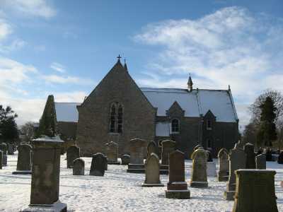
Edrom
Edrom is a rural Parish in east central Berwickshire being bounded on the north by the Parishes of Bunkle and Preston and Chirnside, on the east by the Parish of Hutton, on the south by the Parishes of Whitsome, Swinton and Fogo and on the west by the Parishes of Langton and Duns.
The Diary of the Rev. John Hastie, Minister at Edrom 1797 to 1822 transcribed by Ronald Morrison.
Only pre 1855 memorial records have been transcribed (see below).
See our sales list for full details and cost of postage.
Volumes available for consultation within our Archive
Pre 1855 Memorial Inscriptions of Berwickshire by David Cargill.
The Churches and Churchyards of Berwickshire by G.A.C. Binnie.1995.
Transcript of the Minute Book of the Burgh of Barony of Dunse 1753 to 1800 by Ronald Morrison.
Rutherford's Southern Counties Register and Directory 1867.
The House of Blackadder, Mrs. D. K. Swan (Berwickshire Naturalists' Club Vol 42)
County Directory of Scotland 1912 - Borders Towns and Villages.
CD-ROM The Churches and Churchyards of Berwickshire by James Robson 1896.
CD-ROM Slater's Directory of Berwickshire 1903.
CD-ROM Land Ownership Commission Report 1872 -1873.
Magazine Articles
Please note that the heading Author includes persons who have compiled or transcribed records; and that the topics indexed, and the synopses are subjective opinions. See the Sales List to buy copies of the magazines containing articles in which you're interested.
Title
Synopsis
Size Description
Issue No
Author
Full of Egotism, Diaries of Rev John Hastie
This is the text of Ronald's talk to the Society on 21st March 2004.
It was about a diary which should appeal to those with an interest in local history, a snapshot of life in a rural Parish between 1797 and 1822, and for those connected to Edrom - an opportunity to �meet the ancestor�.
2 pages or more
55
Ronald Morrison
New Society Publication - Edrom
An account of the publication by the Society of the Edrom Monumental Inscriptions etc. also some background on the parish and persons associated.
2 pages or more
91
Edrom Monumental Inscriptions
A report on the publication of the Edrom Monumental Inscriptions C.D.
less than 1 page
93
Edrom and Preston Road, Duns burials
Report of a donation to the Society of copy records relating to burials at Edrom Churchyard and Preston Road, Duns Churchyard.
less than 1 page
96
'What a Mine of Capability!' - Victorian Church Extension and the Edrom Subscription List of 1839
A review of the survey of the denominations of families within Edrom parish in 1835 organised by Rev. Alexander Cuthbertson (835 established church individuals from a population of just over 1,400). The survey found the church to be too small and subscriptions were collected (�864 9s 2d) to rebuild the church under the auspices of the Church of Scotland's Extension scheme, but this was never to be as the split in to the church by the founding of the Free Church of Scotland 1843, meant there was no longer a need for additional space. However, it was still rebuilt and reopened in 1886. Since then the fall in population and religious affiliation has meant uniting with Chirnside + Bonkyl and then Duns + Bonkyl. Currently there are twice-monthly services to a congregation of 12 Sunday 15th March 2020. A list if the subscribers including a third from working class families ranging from 1d to �1 10s per subscriber.
5 pages or more
104
Kenneth McLean
From Coldstream to Canada
The Galbraith history from Coldstream to Toronto University. A comprehensive account of the Galbraiths.
3 pages or more
26
James Burns
Kelso Mail Extracts
Six birth announcements published in the newspaper in 1803 and 1804.
1 page or more
73
Marjorie Gavin
Robert Fortune
An account of the life of Robert Fortune born at Edrom who became a renowned botanist and undertook several journeys (often proving quite perilous ) to China and the Far East - Many plants are named after him and he can probably lay claim to be the founder of the tea industry in India having smuggled plants out of China to help establish this. Buried at Brompton Cemetery, London where a memorial to him has recently been restored.
3 pages or more
80
Ronald Morrison
Waterloo and Beyond
Some notes by the author on his attempt to find gravestones and memorials to those who died in the Napoleonic Wars.
less than 1 page
88
Kenneth McLean
Pierre Merlet and the Humes of Broomhouse
An account of the author's researches to prove that Helen Home of Broomhouse was responsible for the smuggling out of France during the French Revolution of the infant Pierre Merlet who later became a distinguished linguist.
6 pages or more
90
David Wesley
Uncleanness at Edrom
A tale of impropriety extracted from the Edrom Session Records.
1 page or more
86
Ronald Morrison
Brown's Self Interpreting Family Bible
George Brown of Horncliffe brought into the offices the very large Brown family bible. Lavishly illustrated, it also included Family Register page. A transcript of the text is presented. It includes members of the Robertson family from Alexander Robertson (b. 1829 in Simperon Mains) and his wife Margaret (b. 1825 in Swinton) through to Georgina Dickson Robertson and Mary Dickson Robertson born in 1871 in Monkerstones, Fogo. All names registered were from the Borders. Research has confirmed more of the family up to the George Brown who donated the bible.
less than 1 page
110
Editor
Map of Edrom from UK Great Britain, Ordnance Survey one-inch to the mile (1:63,360), 'Hills' edition, 1885-1903 by kind permission of the National Library of Scotland. Use the control at the top left of the map to zoom in or out and drag the map left, right, up, or down as you wish.
Map of Edrom from UK Ordnance Survey Historical Maps from 1919-1947 by kind permission of the National Library of Scotland. Use the control at the top left of the map to zoom in or out and drag the map left, right, up, or down as you wish.
20 Most Common Surnames
The 20 most common surnames on gravestones recorded by us in the Edrom monumental inscriptions volume are (number of gravestones in brackets): JOHNSTON (43), ROBERTSON (41), PATERSON (39), BLACKADDER (33), WILSON (30), DICKSON (28), ANDERSON (28), BROWN (26), LOGAN (26), PURVES (26), TURNBULL (22), BOSWALL (19), BELL (19), SWINTON (18), GIBSON (18), COCKBURN (17), HOGG (17), FORREST (17), LOGAN HOME (17), DODDS (16).
Other Sources
The Statistical Accounts of Scotland 1791-99 vol.1 p.116: Edrom, County of Berwick (click "browse scanned pages" and insert Parish name)
The Statistical Accounts of Scotland 1834-45 vol.2 p.266: Edrom, County of Berwick (click "browse scanned pages" and insert Parish name)