Our archive and search room is now open on Tuesdays and Thursdays from 10am to 4pm. Keep up to date via our Facebook page and Twitter.
Broughton, Glenholm & Kilbucho
The combined parishes of Broughton, Glenhom & Kilbucho are on the western border of Peeblesshire. Glenholm, Kilbucho & Broughton were combined in 1794 and in 1803 a new church was built at Calzeat. They are now one of the linked parishes of Upper Tweeddale. Glenhom and Kilbucho are bounded by Lanarkshire but Skirling is interposed between Broughton and Lanarkshire. Kirkurd is to the north with Stobo and Drumelzier to the east. John Buchan, the author, had strong family ties with Broughton. The village war memorial is beside the main road.
Old Parish Records cover the periods:
Broughton
Births: 1697-1854 (Mothers' names are not recorded until 1763)
Marriages: 1697-1854
Deaths: 1828-1854
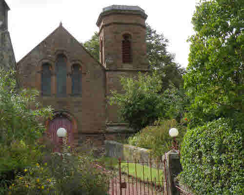
Broughton, Glenholm & Kilbucho Parish Church
Glenholm
Births: 1747-1854
Marriages: 1784-1795
Deaths: 1783-1851, 1822-1851
Kilbucho
Births: 1749-1854 (Mothers' names not recorded until September 1791)
See our sales list for full details and cost of postage.
Volumes available for consultation within our Archive
60 Rural Years by T T Kilbucho
A Living Village
Broughton Free Kirk and thereabouts, 1843-1943
County Directory of Scotland 1912 - Borders Towns and Villages
Extracts from the Records of the Burgh of Peebles, 1652-1716 (CD)
John Buchan's Tweeddale by the John Buchan Society
Letters of Blackstocks of Broughton to New South Wales, Australia by J and C Blackstocks
Millennium Memories - Parishes of Upper Tweeddale
Old Broughton, Drumelzier, Manor, Stobo and Tweedsmuir
Parish of Broughton Deaths 1820-1844
Parish of Glenholm Deaths 1822-1851
Pre 1855 Monumental Inscriptions of Peeblesshire, Scottish Genealogical Society
Rutherford's Southern Counties Register and Directory, 1867
Magazine Articles
No articles currently.
Map of Broughton from UK Great Britain, Ordnance Survey one-inch to the mile (1:63,360), 'Hills' edition, 1885-1903 by kind permission of the National Library of Scotland. Use the control at the top left of the map to zoom in or out and drag the map left, right, up, or down as you wish.
Map of Broughton from UK Ordnance Survey Historical Maps from 1919-1947 by kind permission of the National Library of Scotland. Use the control at the top left of the map to zoom in or out and drag the map left, right, up, or down as you wish.
Other Sources
A History of Peeblesshire (3 Vol)
The Buildings of Scotland - Borders
The Statistical Accounts of Scotland compiled initially between 1791 and 1799, with a subsequent edition between 1834 and 1845 are a valuable record of the geography, history, economy, people and customs recorded by local ministers. You'll need to search for the parish name