Greenlaw is centrally situated in the County of Berwick being bounded on the north by
the Parishes of Longformacus, Polwarth and Fogo, on the east by the Parish of
Eccles, on the south by the Parishes of Hume and on the west by the Parish of Gordon.
Old Parish Birth Records exist from 1691 to 1854.
Marriage Records from 1648 to 1854.
Death records exist from 1719 to 1776 and from 1780 to 1854.
1841 census Greenlaw.
1851 census Greenlaw.
1861 census Greenlaw.
Greenlaw Burials 1780-1854 by Nigel Hardie.
Greenlaw Memorial Inscriptions transcribed by Carol Trotter (including poll
tax, militia list, transcription of War Memorial and list of ministers) was
published by the Society in 1996. Unfortunately this is currently out of print.
See our sales list for full details and cost of postage.
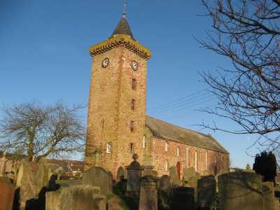
Greenlaw Parish Church
Volumes available for consultation within our Archive
Greenlaw Memorial Transcriptions as above.
Pre 1855 Memorial inscriptions of Berwickshire by David Cargill.
List of Elders, Deacons and Church Officers of Greenlaw Free Church 1885.
The Churches and Churchyards of Berwickshire by G.A.C. Binnie.
C.D. The Churches and Churchyards of Berwickshire by James Robson 1896.
Index to Particular Register of Sasines for Berwickshire.
Pigot's 1837 Directory of Berwickshire and Roxburghshire.
Rutherford's Southern Counties Register and Directory 1867.
C.D. Slater's Directory of Berwickshire 1903.
County Directory of Scotland 1912 - Borders Towns and Villages.
Magazine Articles;
Please note that the heading Author includes persons who have compiled or transcribed records; and that the topics indexed, and the synopses are subjective opinions. See the Sales List to buy copies of the magazines containing articles in which you're interested.
Title
Synopsis
Size Description
Issue No
Author
Death in the Borders: 19th Century Border Murder Cases
Book review. Author: Norrie McLeish. Border Murder Cases- a great deal of research has gone into this volume. Gypsies, landlords, and farm workers, and many others. are included.
2 pages or more
30
Hugh K. Mackay
The poor, crime and punishment, and the power of the Kirk in the Borders, 17th and 18th Centuries
When paupers died, the contents of their houses were sold by public group. This is an account of one sale and the strength of the Kirk.
2 pages or more
31
M. C. Lawson
Greenlaw Jail
List of prisoners in Greenlaw Jail in the 1851 census.
1 page or more
35
Carol Trotter
Greenlaw - an Ancient County Town
Some notes on the book 'Greenlaw - an Ancient County Town' by James Denham.
less than 1 page
89
A Glimpse of Greenlaw
Book review. Authors: JD Smith. "A Glimpse of Greenlaw 1900-1930". 341 pp fully illustrated history of Greenlaw. The churches, the school, the Parish Council, the Temperance Movement and clubs and associations. The politics of the period and the impact on locals is described. can be bought through the Society.
less than 1 page
106
Ronald Morrrison
Clan Galbraith - Royalty to Refugees
A summary of the torrid history of the Galbraith clan and its associations, describing the branch that ended up in the Scottish Borders, back to John Galbraith in Greenlaw in late 1600s/early 1700s. His son John went on to be a tenant farmer in Humbie, another son (also John) to Symington, and all other siblings to work on the land. By the mid 19th century the merchant arm of the family moved to London.
1 page or more
105
Alastair Galbraith Ann Galbraith
The Berwickshire Leitchs Part 2
Following Part 1 in Ed. 105, further research into David Learmouth living at 8 years old with the authors' husbands great great grandfather James Leitch in 1851 at Fogo? Did he become David Leitch pharmacist in Greenlaw? Examination of the 1871 census shed a light on the complicated story of David and his family (wife Jessie and children David (2) and James Findlay (1) based around Hillhead (Glasgow). Prior David apparently of Makerstoun, Wester Row Greenlaw, Dunse Road Greenlaw, probably the illegitimate and then adopted son of James Leitch. He returned as the first pharmacist in Greenlaw. He died in 1905 aged 61, leaving 4 sons and a daughter. His son David also trained as a pharmacist; his siblings Charles Blair, Matthew, James Findlay and Jessie McLeod all moved away from Greenlaw.
3 pages or more
106
Diana Leitch
Greenlaw and Melrose Brownlees
New member Graham Somerville has been able to confirm speculation in Issue 105 regarding the Berwickshire Brownlee ancestors. Thomas Brownlee and his twin Robert were born 1851 at Greenlaw of parents Alexander Brownlee (1797-1874 - Greenlaw) and Mary Ann Hood (1807 (Coldstream)-1887(Greenlaw)). The member has DNA matches to Robert. The family story is further described and evidence seen at Greenlaw Church.
1 page or more
110
Editor
Poor Relief in the 1840s
A review of the operation of the poor relief in the early 19th century. It includes the size of the allowances paid and an estimate of the cost of living at the time.
4 pages or more
71
Peter Munro
Promises Promises
Review of a book 'Promises Promises' written by Norrie McLeish on cases of breach of promise.
less than 1 page
99
Ronald Morrison
Map of Greenlaw from UK Great Britain, Ordnance Survey one-inch to the mile (1:63,360), 'Hills' edition, 1885-1903 by kind permission of the National Library of Scotland. Use the control at the top left of the map to zoom in or out and drag the map left, right, up, or down as you wish.
Map of Greenlaw from UK Ordnance Survey Historical Maps from 1919-1947 by kind permission of the National Library of Scotland. Use the control at the top left of the map to zoom in or out and drag the map left, right, up, or down as you wish.
20 Most Common Surnames
The 20 most common surnames on gravestones recorded by us in the Greenlaw monumental inscriptions volume are (number of gravestones in brackets): WILSON (20), BROWN (18), HUNTER (16), WATSON (15), HENDERSON (14), HUME (14), SCOTT (14), SMITH (13), PURVES (13), TURNBULL (12), THOMSON (12), ROBERTSON (12), YOUNG (11), MILLER (11), REDPATH (11), PRINGLE (10), NISBET (10), FAIRBAIRN (10), ARMSTRONG (10), FRATER (10).
Other Records;
An Old Berwickshire Town - history of Greenlaw from the earliest times to the present by Robert Gibson -
Edinburgh 1905.
Frequent Flitting - Geographical Mobility and Social Structure in mid
nineteenth century Greenlaw by R Houston - Vol 27 Scottish Studies (Journal of
the School of Scottish Studies Edinburgh University).
Scottish Borders Archives, The Hub Hawick hold the following records;
Greenlaw School minutes etc. 1873 to 1919 ref; B/ED/1/55-59.
The Scottish National Archives Edinburgh hold the following records;
Greenlaw Parish Church;
Births 1855 to 1952.
Minutes 1836 to 1861.
Accounts 1779 to 1907.
List of Persons new to Greenlaw.
List of persons removed from Greenlaw ref; CH2/183/7.
Greenlaw Free Church;
Births records 1873 to 1902.
Minutes 1842 to 1874.
Communion Roll 1842 to 1847 - ref; CH3/635.
Greenlaw United Associate Congregation;
Communion Roll 1825 to 1853 ref; CH3/503.
also the following Maps:
1731: Plan of Greenlaw and Polwarth Commons. ref; RHP.224/1.
1842: Plan showing the division of the common land, the village church, mill, Blackadder
Water, roads etc. ref; RHP.224/2.
1866: Estate plan showing boundary between Easter Howlaws and Gordonbank. NAS ref; RHP.339.
Berwickshire Naturalists' Club has published the following articles;
Vol. 5 Greenlaw by the Rev. John Walker.
Vol. 25 An Old Berwickshire Town by R Gibson.
Vol. 28 Brumfields, Ridpaths and Haitlies of Greenlaw.