Our archive and search room is now open on Tuesdays and Thursdays from 10am to 4pm. Keep up to date via our Facebook page and Twitter.
Ayton
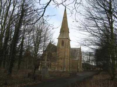
Ayton is on the coast of East Berwickshire, with the Parish of Eyemouth to the north, the North Sea on the east, the Parishes of Mordington and Foulden to the south and the Parishes of Chirnside and Coldingham to the west.
Mortcloth records 1800 to 1819, transcribed by Nigel Hardie.
Mortcloth Records 1820 to 1854, transcribed by Nigel Hardie.
See our sales list for full details and cost of postage.
Volumes available for consultation within our Archive
Berwickshire Miscellany: Ayton and Chirnside by Russell Cockburn.
CD The Churches and Churchyards of Berwickshire by James Robson 1896.
CD Slater's Directory of Berwickshire 1903.
CD Land Ownership Commission Report 1872 -1873.
County Directory of Scotland 1912 - Borders Towns and Villages.
Glimpses of Past in Lammermuir by Norrie McLeish.
Index to Particular Register of Sasines for Berwickshire.
Notes on the History of Ayton by Ramsay Turner.
Pigot's 1837 Directory of Berwickshire and Roxburghshire.
Pre 1855 Memorial Inscriptions of Berwickshire by David Cargill.
Rutherford's Southern Counties Register and Directory 1867.
The Ayton Bard, Robert Mennon by A Mennin (sic).
The Churches and Churchyards of Berwickshire by G A C Binnie.1995.
The History of Ayton and other Personal Recollections by T Ramsay Turner.
The History of Ayton, The Berwickshire Village compiled by Ayton Local History Society.
The Life of Principal John Cairns of Ayton by John Cairns.
Magazine Articles;
Please note that the heading Author includes persons who have compiled or transcribed records; and that the topics indexed, and the synopses are subjective opinions. See the Sales List to buy copies of the magazines containing articles in which you're interested.
Title
Synopsis
Size Description
Issue No
Author
The Ayton Bard
This is in issues 16 and 17.
Robert Mennon was a well known Borders bard and contributed to many Scottish weeklies.
5 pages or more
16
A. Michael Mennim
The Bradford Family Search
A tale of family that moved from Northumberland to Berwickshire. All were farm servants some labourers some farm stewards. There are irregular marriages, name changes and a possible pioneering birth using chloroform.
6 pages or more
72
Bill Bradford
Ayton History Society
Note on a booklet 'The History of Ayton and other personal Recollections published by Ayton History Society; includes extracts from the work of T Ramsay Turner, an account by an unknown author entitled 'Happy Childhood Reminiscences of 1876' and some works by the local poet Robert Mennon.
less than 1 page
81
Ayton Church 150th. Anniversary
History of Ayton Parish Church, celebrating its 150th anniversary.
less than 1 page
93
Bill Stewart
The History of Ayton - A Berwickshire Village
Notes on a book, 'The History of Ayton and other personal recollections' published by Ayton History Society.
less than 1 page
99
Bill Stewart
Local Histories - The History of Ayton - A Berwickshire Village
Review of a volume about the history of Ayton, including old photographs. It looks in detail at the businesses, shopkeepers, schools, churches, sports clubs and societies
less than 1 page
100
Ronald Morrison
The Ayton Bard
Robert Mennon 1797-1885
Book review. Author: Michael Mennon. This is a two part article abridged from the book of the title written by A. Michael Mennon. A copy of the complete book together with maps, photographs and poems is in Scottish Borders Council Library Headquarters with a family tree.
4 pages or more
15
A. Michael Mennon
The Aytons of Ayton
The parish of Ayton from the Norman family De Vesci who changed their name to Ayton to a history of the village.
2 pages or more
17
James Eaton
'Fair' Suspended
An account of how the writer discovered three generations his ancestors of the name Fair in the Churchyard at Ayton.
1 page or more
84
Bill Stewart
Memories of Ayton
Mrs Patricia Payne was so interested in the articles on 'The Ayton Bard' that she felt the need to record some of her memories of Ayton before all was forgotten.
less than 1 page
18
Patricia Payne
Ninewells Waulkmill, Chirnside
Some investigation by the author finding Ayton church memorials for his x4 and x5 great grandparents - Paternal side Edward Fair (d. 1847) and wife Elizabeth Wood (d.1857), their son William Fair (d. 1801) and wife Christina Darling (d. 1825). Dates? Maternal side - William Martin (d.1794) and wife Isabel Jeffrey (d. 1790), and Thomas Martin (d. 1841) and wife Hellen Cockburn (d. 1851). Thomas - at the time of erecting the stone was working and living in Ninewells Waulkmill, Chirnside, and lived there for 50 years.
less than 1 page
106
Bill Stewart
Map of Ayton from UK Great Britain, Ordnance Survey one-inch to the mile (1:63,360), 'Hills' edition, 1885-1903 by kind permission of the National Library of Scotland. Use the control at the top left of the map to zoom in or out and drag the map left, right, up, or down as you wish.
Map of Ayton from UK Ordnance Survey Historical Maps from 1919-1947 by kind permission of the National Library of Scotland. Use the control at the top left of the map to zoom in or out and drag the map left, right, up, or down as you wish.
20 Most Common Surnames
The 20 most common surnames on gravestones recorded by us in the Ayton monumental inscriptions volume are (number of gravestones in brackets): ANDERSON (59), AITCHISON (50), MARTIN (49), JOHNSTON (40), KERR (38), WOOD (37), PURVES (35), WILSON (32), BROWN (26), SMITH (25), COCKBURN (25), BELL (24), PATERSON (19), RENTON (18), WHITE (17), DARLING (17), SCOTT (17), BURNS (16), HOGG (15), SHEARLAW (15).
Other Sources;
The Statistical Accounts of Scotland 1791-99 vol.1 p.79: Ayton, County of Berwick (click "browse scanned pages" and insert Parish name)
The Statistical Accounts of Scotland 1834-45 vol.2 p.130: Ayton, County of Berwick (click "browse scanned pages" and insert Parish name)